Dolomites Alta Via 2
- Tao Wu

- Oct 2, 2022
- 12 min read
I hiked the Dolomites Alta Via2 from 30/08/2022 to 7/09/2022. The trek from Bressanone (Brixen) to Feltre in Italy took me 9 days to complete. This is a well-known long distance walk. There are plenty of guidebooks and online sources for anyone who is interested. I hope that other people may find my experience and photos useful.
The most common guide for AV2 is the Cicerone guide by Gillian Price. The book divides the hike into 13 stages (i.e., days). The last day from Rif. Dal Piaz to Croce D’Aune (1.5 hr downhill walk) can be easily combined with the previous stage to make this a 12-day walk. I did the walk in 9 days with two shortcuts. On the first day, I took the Plose lift to save myself a long climb in the woods. On day 4, I took a taxi from Rif. Castiglioni to Malga Ciapela to avoid “not so exciting decent and road walking”. For a purist who wants to walk every meter from the beginning to the end, including the both sections wouldn’t make the walk much more difficult. Of course, there are always faster walkers. I met three Spaniards at Passo Cereda, they completed AV2 in 8 days. Is the timing in the book too “leisurely”? It really depends on the individual. In the Rif. Genova, I met two of Australian hikers who planned to walk AV2 in 16 days. They weren’t inexperienced with Dolomites. On the other hand, if one makes each stage shorter, one has a lot chance to take side trips to many summits.
For me the difficulty of AV2 wasn’t the distance walked nor the height gain and loss each day. The difficulties lied in the combination of the steep climbs and descents with the arduous trail condition caused by the loose rocks, the scree filled gullies, the boulder fields, the via ferrate and the exposures. The combined conditions made me (and most of hikers) walk at much slower pace. And it was also tiring mentally. In many other treks, on average I walk 25 km (or bit more) a day, even with ascents over 1000 m. This includes walks in UK, Pyrenees, Alps and Norway. Other walkers whom I met on the trail shared my opinion, for example, the Spanish hikers I mentioned earlier. When we exchanged our thoughts at Corce D’Aune, they told me that compared to the other walks they had done, they needed to concentrate more on AV2. They were very experienced hikers. All three of them had completed the Pyrenees traverse. Two of them had summited Alpamayo (a technical mountain of 5900m) in Peru.
Overall, I would rate AV2 a difficult hike, more so than Tour de Mont Blanc or the Haute Route from Chamonix to Zermatt, but it is massively rewarding in term of mountain sceneries. One also has more “fun” from the multitude of challenges such as Via Ferrate, hands-on-rock scrambling, and walking carefully on the exposed ledge of rocks.
The weather in Dolomites could vary a lot in early September. In the first week of September of 2009, I came to Dolomites for the first time. We walked into a snowstorm. This time it was hot. For the most part, I escaped from rains on this trip. Most of rains happened in the night.
The rifugios in Dolomites are among the bests in Europe. The huts' condition and the food generally are better than those in Switzerland, France, Spain or Norway. The dinners are always hearty and tasty. In the high mountains, the breakfast selections are limited to dry (yes, very dry) breads, jams, and possibly some cheese. I was happy with every rifugio I stayed in on this trip.
Day 1: Bressanone to Rif. Genova

Bressanone is an elegant South Tyrol town. Even people look elegant. There are a few outdoor stores if one needs to do some last-minute shopping. I had to buy a pair of hiking poles because DHL couldn’t deliver the first pair on time, and BA lost my second pair on the flight to Verona.
My hotel, hotel Jarolim, was next to the train station which was the starting point of the AV2. From the hotel I walked to St. Andrea that was about 400m higher than Bressanone. There I found the Plose lift. The gondola whizzed me up to 2000 meters at Valcroce. It was immediately cooler and more pleasant to walk. A further 500m up, there was the Plosehütte.
From there AV2 descended into a valley, then entered Parco Naturale Puez-Odle. It was easy walking until the steepish climb of Forcella di Putia, the first pass of AV2.


After the pass, a nice traverse led to Rif. Genova (or the Schlüterhütte). The hut was popular, and it offered à la carte for dinner. This was a relatively easy day. It rained hard during the night. There was a leak on the roof so that rain dripped on to my bed. Because the dormitory wasn’t full, I just moved to another bed.
The first day’s walk was 20k, 1500m up and 7.5 hrs.
Day 2: Rif. Genova to Passo Gardena
Today I ran into trouble early on. The rain stopped by the time of breakfast but the sky was still cloudy. The cloud-covered mountain landscapes were mystic and dynamic.


After leaving the rifugio for one hour, the trail turned into a long traverse on a scree slope. The rain washed out part of the trail and created steep gullies. One of those was particularly deep. I went down into the gully, but I couldn’t climb up the other side because it was too steep, and the loose rocks gave no food hold or hand hold. Looking back, if I had used my hiking poles, I would probably have got out of the pickle. Instead, what I did was to keep going up in search for a narrower spot to cross. Eventually I climbed to the other side of the gully, but I now was 100 meters above the trail on the 60-degree slope. I managed to get back to the trail by sliding on my butt from time to time. I ended up with some scratches on my arms and legs but otherwise unharmed.
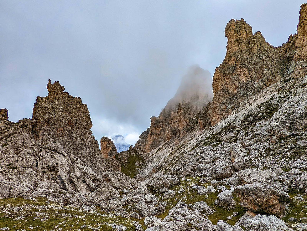
From there I climbed to Forcella della Roa by a scree filled gully which a German walker, who I met later, called “the garbage mountain”. After a stretch of cable assisted section and another pass, I found the Rif. Puez. It was raining slightly, and the scenery looked gloomy. The gully crossing exhausted me physically and mentally. I ate half of my cold sandwich while sitting on a flat rock, feeling a bit defeated.
Then I realized that it was just 12:30pm. I still arrived at the Rif. Puez ahead of the book time. I picked myself up continue towards Passo Gardena. The weather improved. When I reached Passo Gardena (a road junction) after 3 hours, the sun was shining, and the sky was blue. There weren’t too many guests at Rifugio Frara but it seemed to be popular with the DT (Munich-to-Venice) walkers. Other than a Dutch walking the AV2, the rest of 8 people in my dorm room were young Germans tackling the DT. The next day would start with a big climb. After dinner, I went to bed early.
Today’s total was 21k, 1100m up, and 1100 down.
Day 3: Passo Gardena to Rif. Castiglioni


I woke up to the beautiful sunrise. After a quick breakfast, I started towards the Rif. Pisciadu. The first part of the attack was non-stopping zigzags in a dramatic deep gully. After 1 hour, I reached the beginning of the Via Ferrate. It was steep but weather was good, and there were plenty of footholds. Finally, after half hour concentrated effort, I reached an awesome plateau of pale barren rocks. The views of all sides were breathe taking. Rif. Pisciadu situated lonely on this plateau, surrounded by the mountains.

AV2 meandered on the rocky upland. There was no discernible vegetation, but a group of Ibex seemed to be enjoying their breakfast. The landscape was otherworldly. There was more cable assisted sections, and more climbing. Before reaching Rif. Boe, AV2 took me to the summit of Anterass (2900m), the highest point of AV2. The area around Rif. Boe was quite busy. The walk from Rif. Boe to Forc. Pordoi was mostly level. When the Rif. Pordoi first appeared in the view, it did seem to sit precariously on a ledge.


From Forc. Pordoi, it was a steep decent of 600m to Passo Pordoi. To reward this knee-killing workout, I enjoyed my mozzarella and tomato sandwich on the grass by the pass. I was delighted that the difficult part of day was behind me. The rest of day was a undulating traverse cross the valley from the Marmolada. The top of the Marmolad
a was shrouded in the veil of clouds but the view was still indisputably fantastic.

Finally, I descended another 500m to the Rif. Castiglioni by a reservoir. The last 2 hours of walking felt surprisingly tiring at the end of long day. I was glad to see the Dutch walker again. During the dinner, we exchanged some travel tips. He shared his experiences of Cape Wrath Trail.
Today’s total was 19k, 1400m up and 1450m down.
Day 4: Rif. Castiglioni to Rif. Flora Alpina

In terms of walking, this is a relatively straightforward day. The first part to Malga Ciapela was either on the road or in the woods. Following the book's suggestion, I planned to take the bus. However, because the earliest bus was at 10:15 i.e. a bit too late, I shared a taxi to Malga Ciapela with another two hikers. The Dutch walker decided to take a different variant and to have an even easier day.
From Malga Ciapela the AV2 first took a disused military road, then it turned into regular trails. It was constant climbing of 2.5 hours until I reached Forc. Rossa. When I arrived at the Forc. Rossa the clouds came and covered everything. I waited a while without much luck.
After the pass, the trail descended to pleasant pastureland where cows and sheep roamed.
The usual end point of this stage is Passo San Pellegrino but I stayed at Rif. Flora Alpina which was about for 4k from the San Pellegrino. I was very impressed with Rif. Flora Alpina. The food was great and room was clean. My room had an amazing view of Pale di San Martino group in the distance.

Today’s total 12k, 1050m up and 700m down. Nice and easy. 😊
Day 5: Rif. Flora Alpina to Rif. Mulaz

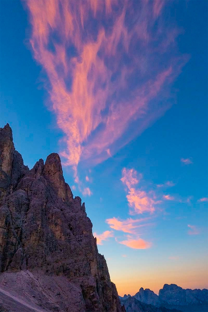
The morning sun painted the mountains and clouds in the rosy colour. It surely felt like a good day ahead of me. I followed the road to Passo San Pellegrino. It was a Saturday and there weren’t many traffic on the road.

The climb started at San Pellegrino but it was gentle. As soon as I passed the treeline, the view was again fantastic. The trail was quiet for a weekend day. I didn’t see anyone until I was close to Passo Valles. My ageing Cicerone guide (published before 2016) mentioned an “ageing St. Bernard” at the Rifugio Valles. And I saw a sleeping giant while I stopped to have a cold Coca-Cola zero. It couldn’t be the same dog, or could it?

After crossing the road, the trail began to climb on grassy mountains. Gradually the trail became more rocky and less maintained while the weather turned threatening. Dark clouds hid the top of mountains, and the chilling winds blew rain drops into my face. A herd of sheep were gathered by a shepherd and a sheep dog. They managed to block the trail for a few minutes. The final hour or so before reaching the Rifugio Mulaz had many steep climbs with the helps of cables and ladders. Finally the Rif. Mulaz revealed itself situated on a magnificent rock plateau with walls of mountains behind.

Many would agree that Mulaz is one of the best mountain huts in the Dolomites. It was particularly welcoming when the weather was cold, windy and rainy. A plate of hot pasta and pint of cold beer made me very happy.
Today’s total was 16k, 1290m up and 550m down.
Day 6: Rif. Mulaz to Rif. Pradidali
The Cicerone book describes the stage from Rif. Mulaz to Rif. Rosetta as difficult. It started with a Via Ferrate to the Passo delle Farangole. There were some exposed sections so that many hikers worn the harnesses and helmets. The climb was steep and the decent on the other side was equally tricky. I met a solo hiker from Israel at Rif. Mulaz. We walked together today.


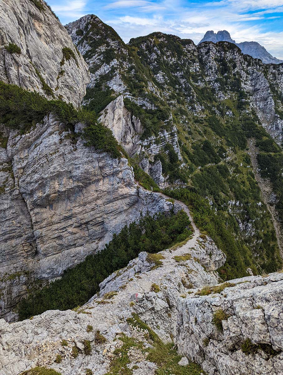
After getting down from the pass, the AV2 began a long traverse above the Val delle Comelle on the exposed trails cut out on the rugged mountain side. There were many cables and short ladders fixed on the mountain for walker’s protection. We went on at a meditative pace, but the weather was good and the view was tremendous.

After about 4 hours, we reached Rif. Rosetta. This was another Rifugio sitting in a moonlike landscape. Because there were two lifts nearby, the trails surrounding the rifugio were fairly “crowded”. Tamir, the Israeli walker, and I had lunch at the Rif. Rosetta. After lunch we said goodbye. I carried on towards Rif. Pradidali.

The first hour after Rosetta was on a well-maintained trail. With a turn at a corner, it started a long stretch of Via Ferrate. Signs in Italian and German warned inexperienced walkers. Eventually after one more mountain pass, I saw the Rif. Pradidali situated below the sharp peaks of Cima Pradidali. If you like the barren rocky landscapes, as I do, this is a magnificent day.

The total of today was 12.5k walked, 950m up and 1242m down.
Day 7: Rif. Pradidali to Rif. Cereda
From Pradidali I took the lower alternative to Rif. Trevisio. It started with the usual zig-zag down on the loose rocks. Then a pleasant walk in the forest followed. Periodically I got a peek of the granite mountains of the Cimonega chain.
About 30 mins before reaching Rif. Trevisio, I saw a junction singed for Forc. d’Oltro. After consulting my map, I went directly to the forcella. The climb to the forcella was steep but not difficult. There was only one fellow hiker on the trail. He was a local. We chatted a bit at the forcella. As I pressed on towards Cerada he turned back to Rif. Trevisio. The day still felt hot and humid.
The first 200 meters of the decent was steep but then it turned into a long traverse on the side of mountains above a wide valley. Across the valley, I could see the pale white peaks of the last two stages in the distance.

After undulating among the wide flowers for an hour or so, the AV2 reached a “forest” of stone pinnaces and turning sharply downward. The strange rock formations sometime blocked the trail, and they forced me to scramble. There was nothing overtly difficult, just a bit tiring after a while.
Eventually I passed the rocky sections and went into a forest. Recent tree disease caused a lot of dead trees. Some of the falling trees blocked the trail and added some challenges in route finding. After half hour, I found the family-owned Rif. Passo Cereda. The facilities were excellent (unlimited showers) and the food was good too.


Today’s total was 14.5k, 1060m up and 2000m down.
Day 8: Rif. Cereda to Rif. Boz
The Cicerone guide claims that this is the most challenging day on the entire AV2; in particular, one needs to be very careful to approach Forc. Comedon because of the erosion near the top. Alarmed by the experience on the day 2 near Forc. della Roa, i.e. my struggling on the scree filled gully, I decided to enlist some help. The nice people at Rif. Cereda gave me a reference to a mountain guide company. I hired a guide to “guide” me to Rif. Boz.

My guide Eric met me at 8:00 am. Eric was a lanky and fit Italian who was born and grew up in the Dolomites. Although he studied classics in the university, he had been working as a mountain guide for more than 20 years. He could guide rock climbing, ski touring, canyoneering, and Via Ferrata trips. Today must have been one of the easiest working days for him because he really didn’t have to do more than just walking with me and pointing out a few features in the mountains occasionally.
The climb to Forc. Comedon was steep and tricky in places, but the difficult section (according to the Cicerone book) close to the pass had been improved since the book was written. Now, there was a maintained the trail for the last 200 meters so that one didn’t need scramble on the loose rocks.


So, the day caused many anxieties turned out to be uneventful. However, I was happy to have Eric as a walking companion who pointed out the big wall climbing routes; told me the history of Parco Naturale delle Dolomiti Bellunesi; and suggested that we had a dip in the emerald pool under a waterfall. The water was cold but it was refreshing for a humid day.

When we arrived at Rif. Boz, it was only 2:30 in the afternoon. After having lunch and sharing a beer with me, Eric took a nap under the trees until his helicopter pilot friend picked him up in a helicopter. Eric was truly travelling in style.
The Rif. Boz was just two large log cabins. There were only 4 groups staying there that night: 3 Spanish walkers, two friends from Australia, an American family of three and me. Dinner was tasty local produces. After we chatted about walks, mountains, Italian and Basque food, somehow the topic moved on to the homemade grappa of which all the rifugios had plenty. The dinner ended with all of us having two shots of grappa. This was one of those evenings from a hiking trip that one would always cherish.
The total today was 11.5k walked, 1145m up and 940m down.
Day 9: Rif. Boz to Croce d’Aune
This stage in the book ends at Rif. Dal Piaz but I decided to walk another 1.5 hr to the road junction Croce d’Aune to catch a bus or to get a taxi to Feltre.

A thunderstorm came over in the night. While the rain had stopped in the morning, the rolling clouds spread out in the valley and spilt over the top of the mountains. I started off towards Passo di Finestra after a quick breakfast.
After the pass, the trail went over to the other side of the mountain chain. The trail was very narrow and exposed for two hours until Sasso di Scarnia. There were many sections which I would not have felt comfortable walking without the help of cables. The worst bit was a 10-meter slab of rock under an overhang. The rain created a stream running on the surface of rock. When I walked gingerly over the rock, I puzzled why no one fixed a cable here. Anyway, I survived, and the rest were straightforward.

Around 1 pm I arrived at Rif. Dal Piaz where I had my lunch and pulled my back muscle. From Rif. Dal Piaz, it took me another one and half hour to Croce d’Aune where I met the three Spaniards outside a bar. We toasted the successful finish of AV2 with a spritz each.
The last day’s total was 20k walked, 990m up and 1700m down.


Comments